![]()
Dublin City Council has launched the results of Google’s Project Air View initiative, which measured the air quality of the city’s streets over a period of 16 months and gathered over 50 million pieces of data.
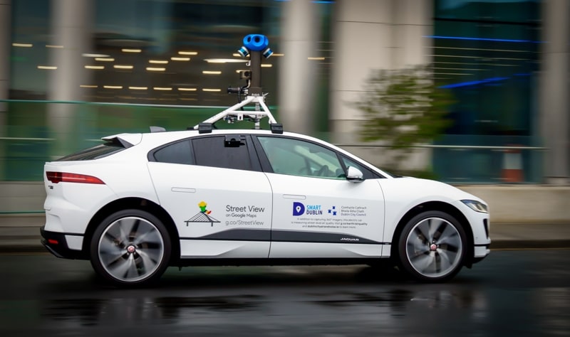
The project was delivered in partnership with the City Council’s Smart Dublin programme, with data captured by Google’s first electric Street View car equipped with Aclima’s mobile air sensing platform.
The data is now openly available to the public to support further research, and to increase awareness of air quality levels across Dublin.
The mapped, street-by-street air quality data is a first for an Irish city, and provides unique insights that will enable the Council, businesses and citizens to work collaboratively to improve air quality for Dublin.
All data is now available to view on Google’s Environmental Insights Explorer and on Smart Dublin’s open data platform, while a 3-day air quality data hackathon will take place in Google Ireland from the 24th-26th February (https://airqualitydatahack.com/)
Speaking at the launch of the data this morning, Lord of Mayor of Dublin, Caroline Conroy said, “Knowing the status of Dublin’s air quality and its impacts on city life and health, are very important. This project captured over 50 million air quality measurements at 5 million locations across the city with the car covering over 30,000kms distance. Project Air View is enabling new insights into air quality across the streets of Dublin. Having these local insights is just the beginning of the journey, we now need to explore the findings and use them to help improve the lives and health of Dubliners.”
The project determined levels of six pollutants such as Particulate Matter (PM 2.5), Nitric Oxide (NO), Nitrogen Dioxide (NO2), Carbon Monoxide (CO), Carbon Dioxide (CO2) and Ozone (O3) in the air. When benchmarked against the provisions of the EU Air Quality Standards 2011, overall, the Capital’s air quality is good. This is confirmed in the results from Project Air View. However, as this data captures street-level insights, for the first time, it is possible to visualise the variability of air quality levels across Dublin. For example, the streets along the quays on either side of the River Liffey in the City Centre show relatively elevated NO2 levels compared to other streets which could be higher, on account of the congestion levels on these quays.
According to Martin Fitzpatrick, Principal Environmental Health Officer with Dublin City Council, “We are just taking our first step in analysing and gaining insights from this significant data capture initiative. The real and exciting challenge now is how we use and share these insights. Collaboration is the key to find solutions that continue to improve the air quality and protect the health of our citizens across the City.”
Paddy Flynn, Vice President of Google Geo Operations said,
“Google is delighted to have collaborated on this important environmental initiative with Dublin City Council and bringing Project Air View to Ireland for the first time. Google is committed to playing its part in making the communities in which it operates cleaner and more sustainable.”
Jamie Cudden, Smart City Lead with Dublin City Council speaking about the new technology said, “This is a great example of how Dublin is able to build partnerships with innovative companies such as Google and Aclima to support the Smart Dublin programme. We are delighted to be the first Local Authority in Ireland to engage on the Project Air View programme. This is yet another example of how smart technology can support better planning and climate action in cities. We are really looking forward to seeing what practical solutions and interventions can now be developed as a next step, and how this can enable greater citizen participation.”
Speaking at the launch about the importance of citizen science, Francesco Pilla, Professor in Smart Cities and Urban Environment in University College Dublin said, “We know Dublin, like many other cities faces challenges related to climate change and to the environment. From what we’ve seen both academically and in real-time, the best way to achieve solutions to issues like these, for example, improving air quality, is by including citizens. Through doing that, we make Dubliners aware of the problems the city faces, while also encouraging them to take action and become collaborative partners. Citizen Science also underlines the importance of research into new challenges, and for public officials and citizens alike to be curious and to be able to continue to solve historical problems to bring about a better future”
Dublin City Council have released this data openly and are encouraging people to view and use the data. To encourage collaboration, Dublin City Council is hosting a data hackathon from 24th to 26th February at The Foundry, Google Ireland. This hackathon will bring together skilled experts and interested amateurs to look at the data from different perspectives, creating new insights that can help to improve air quality in our cities and communities. To find out more or to register click here.